Saturday, December 5, 2009

Day 30 – Big Bend

No Travel Mileage Today

We did not get any snow last night but we did get a dusting of snow this morning.

The temperature forecast for tonight is in the mid 20s. Tomorrow is clear skies and warming to the 50s and then Sunday in the 70’s.

We took the Ross Maxwell scenic drive today.

IMG_0002

The building in the picture looks like an active ranch but it was abandoned in 1945. The  foreman’s house is constructed of native materials: reed ceiling from the river, timbers from the mountains and large stones from Blue Creek Canyon.

IMG_0003

Many of the mountains in the park received a light cover of snow during the night.

IMG_0004

IMG_0005


Some brush and trees along the way were covered with ice.


IMG_0008

Carousel Mountain actually looks like a carousel. It consists of magma from ancient volcanoes. Over the millions of years the softer ash and soil eroded away.


IMG_0009

Mule Ear Peaks is another example of volcanic action and erosion in this valley .

IMG_0011 Cerro Castellan is made up of a high stack of volcanic rocks and is an important landmark  IMG_0010along the Rio Grande. The layers in the Cerro Castellan reveal millions of years of volcanic events. Stack in this tower are several lava flows volcanic ash deposits, with layers of gravel and clay periods or erosion between eruptions.

Nearby is an area of white tuff beds and black, basaltic boulders.


IMG_0015

IMG_0014 This store is the oldest building in the park and was used from 1900 to 1925.


Seventeen-mile long Santa Elena Canyon separates the high mesas of the massive LowerIMG_0017 Cretaceous limestone into the Mesa de Anguila on the United States side the Sierra Ponce on the Mexican side. Geologists believe that during the Miocene and Pliocene Epochs (about 50 million years ago), mountain building caused large uplifted faults blocks to form a series of intermundane basins. As the basins filled with water and debris, they overflowed into one another forming interconnecting valleys which eventually established the through-flow drainage of the Rio Grande. Down-cutting by the river cut the narrow gorge of the Santa Elena Canyon.

Friday, December 4, 2009

Day 29 - Big Bend, Texas

No Travel Mileage Today.

Last night was cold and windy. The forecast for tonight is colder with a possibility of up to an inch of snow. Today was fairly overcast.

We did go exploring today and to our pleasant surprise there is quite a bit of history along with things to see.

We have no internet or cell phone service where we are camping. We were able to find a spot about 5 miles from here that is high up on a hill where I got 2 bars of single strength on the cell phone and was able to connect to the internet. The connection is rather slow so I am limited in what I can send and receive.

IMG_0001We are camped within a few hundred feet of the Rio Grande Rio.  As IMG_0002you can see the trees have started to change to their fall colors.

Our first stop was a floodplain farm house on the Rio Grande. To transform the desert into a IMG_0003productive garden, settlers in the 1920s dug a system of irrigation ditches and pumped water  from the river. For a few decades the fields yielded melons, corn and cotton. There was a rock by the river that had walking sticks along with a few other trinkets, a note listing the prices of items and a jar for the money. Raija thought that some down and out person was trying to make a buck. My thought was that there must be a small Mexican Village across the river and that it was a Mexican enterprise.
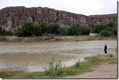
IMG_0006

IMG_0007

Rio Grande River by old farmhouse

The route to our next stop solved the mystery. There was a pull out overlooking the river. IMG_0009 Across  the river was the Mexican town of Boquillas. The overlook hadIMG_0010 several large rocks with walking sticks, jewelry, beaded figures, etc. Across the river on the Mexican side was a canoe and by the canoe were several stock piles of walking sticks. It seems that Mexicans from the village slip across the river, restock the IMG_0008 shopping rocks and collect the money from the jars on at least a daily bases. There is no legal border crossing for over 100 miles so appears that IMG_0012both the Park Rangers and the Border Patrol must look the other way to this little operation.
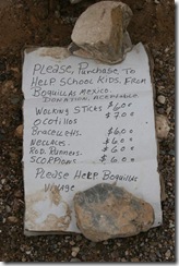
IMG_0013


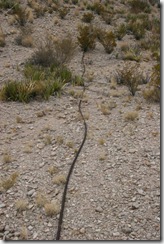
IMG_0014 Our next stop was the site of an old tramway that carried zinc, silverIMG_0015 and lead ore across the Rio Grande from a mine in Mexico to railroad in Marathon, Texas. The tramway started at the old Puerto Rico Mine above Boquillas, Mexico transverse six miles and terminated in the Ernst Valley. Four 6 mile-long cables carried 90 buckets at a time, delivering 7 tons of ore per hour, it was then an 85 mile wagon trip to the railhead in Marathon.

IMG_0016

IMG_0017


Cables from Tramway


IMG_0018

The last stop of the day took us to Hot Springs, Texas. CharlesIMG_0022 Livingston built a house, store / post office, motor hotel and hot springs bath house in the late 1920’s and early 1930’ along the banks of the Rio Grande River and Tornillo Creek.

The buildings are typical construction of time and area using native rock and local materials.

IMG_0024

Post Office Store

Charles believed in the healing powers of the springs and encouraged tourists to sample the  healing waters of the Hot Springs spa and fish for large catfish.

The Hot Spring water is considered old water, fossil water, ancient and irreplaceable. Heated by geothermal processes and emerging at 105 F, the water carries dissolved mineral salts reputed to have healing powers.

Research indicates that the hot water is emerging from a pocket of fossil water deposited at least 20,000 years ago. The ancient water is not being replaced and may one day become extinct. The temperature is 105 degrees F throughout the year. The rate of flow in 1936 was claimed to be 250,000 gallons per day. More recent measurements show a slight decrease in flow.
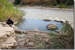
IMG_0028 The two story bathhouse was built over the largest of several hot springs found along this section of the Rio Grande River. Today the foundation is all that remains of the main structure. The bathhouse was built of native rock and jutted into the river channel; its thick walls were angled to cut into the flow of the water during heavy floods. The idea was sound but the river was overwhelming. All that remains today is the foundation that is submerged when the river flow is above tree feet.

IMG_0010Another rock store by the old Hot Springs

IMG_0026

IMG_0025   

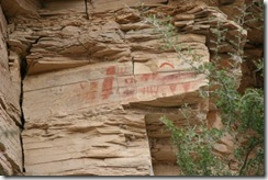
Ancient Indian Art by Hot Springs

Thursday, December 3, 2009

Day 28 Big Bend

Day's Travel mileage 222 total mileage to date 1937 miles

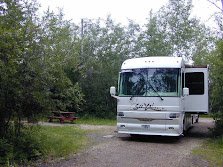
We arrived at Big Bend, one of our main goals of this trip, today. We set up camp at the Rio Grande Village National Park Campground. It is dry camping and with Golden Eagle discount it is $7 per night.

There is no cell, internet, radio or TV here. I did have cell phone coverage on the park road in spots so I will try and post this tomorrow as we drive around to take in the sites.

Big Bend refers to the great southwest Texas U-turn the Rio Grande makes here. In Big Bend National Park roads end at the Rio Grande, the boundary between the United States and Mexico. Three states come together at Big Bend: Texas in the United States and Coahuila and Chihuahua in Mexico.

We arrive too late to take pictures for this post. Look for pictures in future posts that may have to wait until we leave the Big Bend area.

12/3/09 – Found a spot on the road where I can just barely can a slow internet connection. Pictures and most things will have to wait a few days until we move on to a place with better internet connections.

Tuesday, December 1, 2009

Day 27 – Seminole Canyon, TX – Gulf Coast / Rio Grande Trip

Day's Travel mileage 102 total mileage to date 1715 miles

Our original plan stop for today was Amistad National Park on Amistad Lake however the park road was flooded. It seems that we continue to end droughts doing this years travels. It is also a rainy day and only 47 degrees. It would have been dry camping at Amistad and without the sun, no solar power so decided to proceed to Seminole Canyon State Park and spend the night there where there is electric hookup and we can run the heat pumps.

Seminole Canyon State Park was acquired by purchase from private owners in 1973 - 1977 and opened in February 1980.

Early man first visited this area 12,000 years ago, a time when now-extinct species of elephant, camel, bison, and horse roamed the landscape. The climate at that time was more moderate than today and supported a more lush vegetation that included pine, juniper, and oak woodlands in the canyons, with luxuriant grasslands on the uplands. These early people developed a hunting culture based upon large mammals, such as the mammoth and bison. No known evidence exists that these first inhabitants produced any rock paintings.

semnorg300 By 7000 years ago, the region had undergone a climatic change that produced a landscape much like today's. A new culture appeared in this changed environment. These people were increasingly dependent on gathering wild plants and hunting small animals and less dependent on hunting big game. They lived in small groups since the land would not support larger social units for long periods.

Despite the struggle for survival, some of these prehistoric people found the creative energy to paint the pictographs found in Fate Bell and other rock shelters of the Lower Pecos River Country. The distribution of this distinct style is limited to a district which includes a portion of the Rio Grande, Pecos, and Devils River. More than 200 pictograph sites are known to contain examples of their style of rock paintings ranging from single paintings to caves containing panels of art hundreds of feet long. Although numerous figures or motifs are repeated in different locations, the exact meaning of the paintings is buried with the people who painted them.

The first known European in this area was Castano de Sosa, who set out from Monciova Mexico, in 1590 and traversed much of present Val Verde County en route to New Mexico. The U. S. Army was the first American presence in the Lower Pecos. In 1851, Lieutenant Nathaniel Michler made a reconnaissance of the Rio Grande above and below its junction with the Pecos for the United States and Mexico Boundary Commission. After the Civil War, Lieutenant Bullis and his Seminole-Negro scouts operated in the area, and Bullis blasted a wagon road into the Pecos Canyon near the Rio Grande to provide the military with a shorter route between Forts Clark and Davis.

In 1882, construction of the Southern Pacific Railroad reached the present park location. The route to connect El Paso with San Antonio was begun after the merger of the Galveston, Harrisburg, and San Antonio Railroads with the Southern Pacific. The section of railroad in the canyon of the Rio Grande was finally abandoned in 1892, when a new bridge spanning the entire breadth of the Pecos River Canyon was completed. The present bridge was built at the same site during World War II.

Monday, November 30, 2009

Day 26 – Eagle Pass, TX – Gulf Coast / Rio Grande Trip

Day's Travel mileage 210 total mileage to date 1613 miles

Today was one of our longer travel days. We are spending the night in the Wal-Mart parking lot and will continue our journey tomorrow. This is certainly one of the busier Wal-Marts that we had been at, especially for a smaller town. The Mexican city of Piedras Negras is just the across the Rio Grande that divides the two cities and two countries. I image that being just a few blocks from Mexico accounts for the high Wal-Mart traffic.

Eagle Pass was the first United States settlement on the Rio Grande. Originally known as Camp Eagle Pass, it served as a temporary outpost for the Texas militia, which had been ordered to  stop illegal trade with Mexico during the Mexican-American War.

The United States Army established the presumably permanent Fort Duncan on March 27, 1849, a couple of miles upstream from Camp Eagle Pass. The building of the fort was supervised by Captain Sidney Burbank. It was named for Colonel James Duncan, a hero of the Mexican War. After the war, trade flourished under the protection of the fort. The fort was near the trail of westward immigration to California. It also served as an outpost against hostile Apache. It was abandoned and reopened several times. In March 1860, it served as the base of operations against the border assaults arranged by Juan N. Cortina.

Fort Duncan was held by the Confederacy during the American Civil War. On July 4, 1865, General Joseph O. Shelby, en route to offer his troops' service to Maximilian in Mexico, stopped at Fort Duncan and buried in the Rio Grande the last Confederate flag to have flown over his men. In 1870, Colonel William R. Shafter trained Seminole and African American scouts at Fort Duncan. After several decades of deactivation, Fort Duncan was activated as a training camp during World War I. In 1938, the City of Eagle Pass acquired the fort and still operates a museum and a children's library at the site.

In 1850, Rick Pawless opened a trading post called Eagle Pass. In 1871, Maverick County was established, and Eagle Pass was named the county seat. During the remainder of the 1800s schools and churches opened, the mercantile and ranching industries grew, and a railway was built.

General William Leslie Cazneau (1807-1876) founded the Eagle Pass townsite in the 1840s.

250px-Downtown_Eagle_Pass_IMG_0266

Eagle Pass Today

Yes, it was another raining day as you can see the clouds are still following us.


Sunday, November 29, 2009

Day 26 – Falcon State Park, TX – Gulf Coast / Rio Grande Trip

No Travel Mileage Today

We drove around the park today and tried to go to the dam. We were unable to get close to the dam as the road proceeds across the dam to Mexico. There is a US Customs building as you approach the dam and at that point one is committed to end up in Mexico. Raija forgot to bring our passports plus the line of vehicles entering the states was rather long, so we did a U turn and returned to the park.

There is a butterfly area in the park that we explored. The park plants various plants that feed IMG_0004 both the caterpillar and butterfly stages. Although the area is home to over 300 species of butterflies only the Monarch butterflies were here along with one or two other butterflies.  


Saturday, November 28, 2009

Day 25 – Falcon State Park, TX – Gulf Coast / Rio Grande Trip

Day's Travel mileage 95 total mileage to date 1403 miles

Just after leaving the RV park at Edcouch the GPS showed 1315 miles to home and the Silverleaf trip log showed 1315 miles traveled so this morning we passed the half way point of our trip.

IMG_0003

IMG_0004

We are now at Falcon State Park on Falcon Lake.


Situated between Roma and Zapata, Falcon State Park covers 572 acres adjacent to the famousIMG_0006 Falcon Lake. Falcon Dam, which created the 60-mile long lake, was dedicated in 1953. The park opened to the public in 1965. Across the Falcon International Dam, the dam is on the Rio Grande, is Guerrero, Mexico. The Rio Grande River is the International Border between Texas and Mexico. Falcon is a relatively shallow lake and is known for good bass fishing.

IMG_0005Falcon Lake Boat Ramp

The only TV stations available are from Mexico.

Thursday, November 26, 2009

Day 23 – Edcouch, TX – Gulf Coast / Rio Grande Trip


Happy Thanksgiving to all. This will be our first Thanksgiving in a long time that we are not cooking a turkey to share with family. The RV Park is cooking several turkeys and our fellow RVers will be bringing pot luck side dishes. We will be bringing a 4 bean salad and cherry lattice pie as our contribution to the Thanksgiving meal.

We drove to South Padre Island yesterday. It was very disappointing, especially compared to Mustang Island and North Padre Island. The southern tip of the island is too commercialized, the beaches were very dirty and we all had trouble breathing including Mik due to a red tide. We passed on the island’s restaurants. We had a late lunch on our way back to the RV park at an Mexican Seafood family owned restaurant. We had our normal seafood choices, fried shrimp, oysters & okra for me and fried fish & shrimp for Raija.

The wild, bay shrimp definitely had a much better flavor then the foreign farm raised fresh water shrimp in the grocery stores.

We stopped at a local fruit stand and purchased locally grown, tree ripen Texas Ruby Red grapefruits and pineapple oranges. The orange get it names as it’s skin has a pineapple look to it and the oranges actually have a slight pineapple taste.

IMG_0002

IMG_0001 


South Padre Island Beach

IMG_0003 IMG_0005

Kite Surfers

IMG_0006 
Commercial Section of South Padre Island

A Mexican Village was originally developed here in the 1700’s to support Mexican ranchers. IMG_0009The     village was abandoned prior to the U.S. declaration of war with Mexico. In 1846. U.S. forces led by General Zachary Taylor occupied the village on March 24. Taylor erected a depot to receive supplies from New Orleans. The six sided fort named for President Polk. The fort was abandoned in 1850 but the settlement it attracted eventually developed into Port Isabel. Remnants of the fort were visible until the 1920’s.

IMG_0008  A lighthouse was built on the fort’s site in 1853. The lighthouse was a strategic prize for the Confederate and Federal troops during the American Civil War. During the last half of the 19th century, its light projected fifteen miles out to sea to help guide ships to the safety of the Brazos Santiago harbor.

IMG_0012

In 1952 the point that was the fort/depot and then the lighthouse became the focal point of a  state park. It stands today as a well-known Port Isabel landmark.

IMG_0013 IMG_0014


Tuesday, November 24, 2009

Day 21 – Edinburg & McAllen, TX– Gulf Coast / Rio Grande Trip

No Travel Mileage Today

The rain still continues to follow us. No pictures today due to rain. We did however drive to the city of Edinburg and McAllen for a look see. Raija found the World Birding Center in Edinburg that she wants to go back to when the weather clears.

We stopped for lunch at a Mexican restaurant near McAllen and discovered that one can enjoy being in Mexico in this part of the US. We had to quickly brush up on our limited Spanish as the waitress did not speak English.

The forecast for tomorrow is clear skies so South Padre Island is on the agenda. We may have to change our cuisine back to seafood while on South Padre Island.  

Monday, November 23, 2009

Day 20 – Edcouch, TX – Gulf Coast / Rio Grande Trip

Day's Travel mileage 165 total mileage to date 1308 milesIMG_0001

Yesterday evening we had a visitor. According to Raija’s bird folder it is a Great Egret although another possibility it might be Heron. It came to hunt dinner in front of the coach.

IMG_0003 

Today’s travel was 165 miles down the coast to Edcouch, Texas. Edcouch is west of Harlingen, Texas. We will spend several days here exploring the area.

Sunday, November 22, 2009

Day 19 – Last Night At Gulf Waters – Gulf Coast / Rio Grande Trip

No Travel Mileage Today

We have clear skies today.

IMG_0011This morning was an early awake call to go and meet the Polly Anna shrimp boat returning from  her night of trawling. We arrived a little late as she was already docked with a line of people buying shrimp. Both Don and I purchased 10 pounds each of the large shrimp at $6 per pound. Then it was off to the fish cleaning shack to remove the heads and then back to the RV park to prepare the shrimp for freezing.

IMG_0003 We froze all of the shrimp from today’s purchase except for 12 that we will have for dinner tonight.

The rest of the day was spent in camp preparing for tomorrow’s next leg of our trip and just relaxing.


Beach pictures after storm by Gulf Waters RV Park where we are staying.

IMG_0001Looking towards Port Aransas

IMG_0002  
Natural gas platforms offshore

IMG_0003
The Gulf is very shallow here

The sky, water and beach are very clear after the storm. The storm blew out towards the sea and cleared the air over the Gulf. Visibility was excellent today and not a single cloud in the sky. Many people were looking for shells along the beach.

Saturday, November 21, 2009

Day 18 – Aransas Pass, TX – Gulf Coast / Rio Grande Trip

No Travel Mileage Today

This past summer we traveled through Utah, Idaho and Montana. As we made our way through each state the rain followed us. Each state had been in a drought for several years. However, we bought enough rain that all three states declared an end to their droughts while we were there. Well guess what? On  the local news last night, we heard the area of Texas that we are in declared an end to their drought.  I wonder if we might be able to get paid for ending droughts.

Today was overcast and somewhat chilly. We drove to Aransas Pass  and checked out several sea food shops. The shrimp in all the shops were several dollars more per pound then the the shrimp boat so we passed on purchasing more shrimp. The shops advertised crabs but the crabs are out of season so no crabs. The local crabs are the blue crabs. There was a small sea food restaurant by the last sea food shop and it was lunch time. Karen, Don & I had oyster shooters followed by fried oysters. Raija had the gumbo soup.

We stopped by the Polly Anna on the way back to Mustang Island. The captain said that he had sold all of his large shrimp but now that the storm is over, he is going back out tonight. He will be back around 9:00 AM tomorrow. The plan is to make one more run at the Polly Anna tomorrow for more shrimp. We depart Mustang Island Monday, so tomorrow will be our last chance to stock up on fresh Gulf shrimp. 

Friday, November 20, 2009

Day 17 – Gulf Waters RV Resort, TX – Gulf Coast / Rio Grande Trip

No Travel Mileage Today and No Sight Seeing

It started to rain yesterday evening and we had a continuous heavy rain with high winds and lightning all night and throughout most of today. This morning some of the local areas had up to 12 inches of rain with another 2 plus inches of rain forecast today. The last rain band is supposed to be passing through now. The forecast is for it to begin clearing tonight. The forecast is for a nice weekend.

There for a while last night the weather radio was going off every 15 minutes or so with a new warning of high winds and marine warnings. The weather radio has been fairly quiet today with just a few warnings of possible flooding.

The good news is that both the coach and the Hummer received a good wash from the driving rain.  There is no need now to hunt up a car wash to clean the Hummer after driving on the beach yesterday.