Monday, September 5, 2011

Day 67 – New River AZ to Home – September 4, 2011


Today’s Mileage: 148
Total Miles: 4088

The final leg of our trip was uneventful and the traffic home was very light even going through Phoenix. We arrived home around 11:30 AM, started up the house, had lunch and then started unpacking the coach.


Trip Summary

Total Miles: 4089
Total Diesel: 510 Gallons
Average Miles per Gallon: 7.5
Total Trip Cost: $3928
Average Cost per Day: $58.62
Average Cost per Month: $1964

Saturday, September 3, 2011

Days 65 & 66 – Cameron AZ to New River AZ – September 2 & 3, 2011


Today’s 65 Mileage: 166
Total Miles to Date: 3941
Miles to Home: 148

Yesterday’s traffic from Cameron to New River was fairly light however the traffic in the opposite direction was full of campers and vehicles pulling boats.

Today will be our last relaxing day of doing very little before arriving home tomorrow. Hopefully, we will be in between the holiday traffic and we should have the highway pretty much to ourselves. We should arrive home in time to empty the motorhome and startup the house before day gets too hot as Tucson day temperatures are still over 100 degrees.

Some people thought that we were in an accident when they read that we were having the windshield replaced. The actually reason for replacing the windshield was due to a rock strike several years ago. The rock created a fairly large star burst in the lower right section of the left windshield. I filled it in using my repair kit and all was well until this trip. A crack started to grow a little each day. I tried to stop drill the crack and inject more glass repair resin. That stopped the growth for a couple of days but then the crack continued to grow. So while we were at Camp Charlie’s I had the windshield replaced.   

Thursday, September 1, 2011

Day 64 – Cove Fort UT to Cameron AZ September 1, 2011


Today’s Mileage: 293
Total Miles to Date: 3775
Miles to Home: 315

We are now back in Arizona. We are spending the night on the Navajo Reservation across from the Cameron Trading Post. As many of you know, this overnight stop is frequently use by us both outbound and inbound from the north.

I am happy to report that all systems are running normal since leaving Charlie’s Service.

Tomorrow we will make our way closer to Phoenix and spend two nights north of Phoenix to wait out the Labor Day traffic.

Tonight we will have dinner at the trading post. Raija will most likely have a favorite green chili stew (with mutton) and I will have the Navajo Taco.

I have written many times before about the Cameron Trading Post in our previous travels therefore I will not bore you again by repeating it.

Wednesday, August 31, 2011

Day 63 – Sunset Utah to Cove Fort Utah – August 31, 2011


Today’s Mileage: 204
Miles to Date: 3482
Miles to Home: 609

The windshield was installed yesterday around 5:00 PM, which enabled us to get back on the road today. It took a while to settle the account with Charlie’s Service as there is always a hassle with the insurance company on what they will cover. We were finally able to depart Camp Charlie’s around 1:00 PM.

Today’s drive was both a challenge and tiring as there was a strong, gusting crosswind and several long stretches of interstate construction where the lanes were narrow and switching back and forth.

Normally our overnight stop is at the junction of Utah 20 and US 89. Due to our late start we did not make it that far. The next normal stop is Cameron Arizona. We are in striking distance to make it there tomorrow from our present position. That will but us back on normal stop overs from Camp Charlie’s to home.

We should also be a good position to maneuver around the Labor Day Holiday weekend traffic problem. Tomorrow is Thursday and hopefully we will be ahead of the boaters going to Lake Powell for the long weekend.

Friday, the traffic should be in the opposite direction for people getting a head start on the weekend as the holiday traffic most likely will consist of Phoenix people heading north to the high country and the lakes.

The current plan is to position ourselves between Flagstaff and Phoenix on Friday and then wait until Sunday morning to make the final run to home. The thought is that the outbound holiday traffic will be Friday and Saturday, Sunday will be very little traffic and Monday will be the mad rush home.  


Tuesday, August 30, 2011

Day 62 – Camp Charlie’s – August 30, 2011


Raija’s birthday flower bouquet from our son’s Jimmy family was delivered to our coach at Camp Charlie’s.

IMG_0371

Raija now has received three bouquets for her birthday, one of which has been eaten as it was a fruit bouquet from our son Mark and his wife Cindy.

IMG_0334
Fruit Bouquet from Mark & Cindy

IMG_0373
The third bouquet is from me, the one on the right.

We just received word that the new driver’s side windshield has arrived. It is now 4:22 PM here so it is somewhat questionable if it will be installed today.

Day 61 – Camp Charlie’s – August 29, 2011


Today was not a total lost. Mik was groomed at the local Pets Mart. He feels a lot better now that he received a close hair cut as he was getting hot on his walks. He no longer is seeking a little spot of shade like he did on Antelope Island.

Raija also cleaned half of the coach’s carpet. We are pleased with the results using a dry rug cleaner. I will do the rest of the carpet when we return home and the weather becomes a little cooler.

There is a slight chance that the windshield will show up tomorrow but it will most likely be Wednesday.

Monday, August 29, 2011

Day 60 – Raija’s Birthday – August 28, 2011


I rose early in the morning to go shopping for blueberries, a card and roses. I was back before Raija woke and arranged the card and roses for her to find. Raija’s birthday breakfast was blueberry pancakes top off with an egg and bacon.

After breakfast, we were off to Antelope Island as it is too far to the Grand Canyon to celebrate Raija’s big birthday there.

IMG_0347
Looking east from Antelope Island towards Salt Lake City

IMG_0343
Raija’s Big “XX” Birthday on Antelope Island

More than 6000 years ago, the area’s native people inhabited Antelope Island. Later local Indian tribes used the island until the arrival of the white men.

Antelope Island, with an area of 42 square miles (109 square km), is the largest island of 10 islands located within the Great Salt Lake. The island lies in the southeastern portion of the lake, near Salt Lake City and Davis County. Antelope Island was discovered by John C. Fremont and Kit Carson in 1845, when they did their exploration of the Great Salt Lake. They shot a Pronghorn Antelope on the island and in gratitude for the meat they named it Antelope Island.

Antelope Island has natural scenic beauty and holds populations of Pronghorn Antelope, Bighorn Sheep, American Bison, porcupine, badger, coyote, bobcat, and millions of waterfowl. The bison were introduced to the island in 1893. The bison do well because much of the island is covered by dry, native grassland.

IMG_0364
Mik discovered that there is at least one snake on Antelope Island.

IMG_0352
American Bison Relaxing in the Sun

IMG_0354

The Garr Ranch is located at Garr Springs, one of the strongest and most consisted of the 40 springs on the island. Both indigenous and wildlife used this water source long before Garr built the ranch.

The Mormon Church operated the ranch until the mid-1870s. During the era, ranching operations encompassed the entire island. The church herds supported the Perpetual Emigration Fund that assisted Mormon members from Europe in making the trek across the Great Plains to Salt Lake City.

As only improvements on the island were around the ranch, the Federal Government opened the rest of the island to homesteading. By the turn of the century most of the homesteaders had failed to prove their claims and John Dooly Sr. purchased the entire island for one million dollars.

The focus of the ranch soon turned to sheep and the operation expanded to more than 10,000 sheep to become one of the largest and most industrialized ranching efforts in the western United States.

In the 1950s sheep ranching became unprofitable and the operation turned to cattle. The island ranch continued to function as one of the largest commercial operations in the state until the island became a state park in 1981.

IMG_0355
Old ranch barn used for shearing sheep

IMG_0356
View from ranch yard

IMG_0357
Ranch Yard

IMG_0360
Old Corral

IMG_0363
Main Ranch House and Bunk House (Right)


IMG_0366
(Left to Right) Main House, Bunk House & Spring House

IMG_0365

Mik Cooling Off

Antelope Island UT Tour

Saturday, August 27, 2011

Day 59 – Camp Charlie’s Sunset Utah – August 27, 2011


This morning we were busy doing coach chores when to Raija’s surprised a florist delivery van showed up at the coach’s door. The delivery was a very beautiful fruit bouquet from our son and his wife, Mark and Cindy.

IMG_0334
Raija’s Birthday Bouquet from Mark & Cindy

Raija opening her gift video

Friday, August 26, 2011

Day 58 – Camp Charlie’s Service – Progress Report - August 26, 2011


All of the preventive items (oil change, filters, lubrication, etc.) were completed on Wednesday August 24th.

Yesterday authorization was received from the insurance company to replace the driver’s side windshield. The windshield was ordered with an expected delivery of Tuesday or Wednesday next week. Once installed, the coach will need to sit 24 hours so as to provide time for the sealant to set. Currently the windshield is the item pacing our departure for home. Today the new washer/dryer was installed and is currently undergoing a test run.

That leaves just the dash A/C. During the process of locating the leak, one hose on the compressor slipped out of its coupling. The coupling has been replaced and the system is currently being tested to see if the coupling was the culprit.

Camp Charlie’s is four days travel time to home. The windshield replacement may put us into the Labor Weekend so we may have to find a place to wait out the holiday weekend.

Tuesday, August 23, 2011

Day 55 – Camp Charlie’s – August 23, 2011

Today’s Mileage: 144
Total Mileage to Date: 3278
Miles to Home: 811

We arrived at Charlie’s Service in Sunset Utah around 11:00 AM. Gil quickly parked our coach and little Gil started the preventative maintenance immediately after lunch. The easy things are just about completed. Tomorrow the washer / dryer will be removed so it can be determined what went wrong and mostly likely the dash air conditioner will be looked at.

Sunset Utah is just north of Salt Lake City and is directly across Interstate 15 from Hill Air Force Base. Hill Air Force Base is where our son served two assignments ago and is where he was promoted to full colonel.

We had hoped to depart Camp Charlie’s Friday morning but most likely we will be spending the weekend here waiting for parts.

It is a shame that our son and his family are not here as they could have helped celebrate Raija’s important birthday, especially since it looks like we will not be able to celebrate it at the Grand Canyon as she had hoped. The Finnish tradition is that this particular birthday is very important and would be a very special celebration in Finland.

Monday, August 22, 2011

Day 54 –Deer Lodge Montana to Fort Hall Idaho– August 22, 2011

Today’s Mileage: 271
Total Mileage to Date: 3134
Miles to Home: 955

We are now in Fort Hall, Idaho on the Blackfoot Indian Reservation. We will spend the night at the Buffalo Casino RV Park, $20 for full hookups. Tomorrow we continue on to Charlie’s Service, 144 miles, for our annual coach service plus a few repairs.
The driver’s side windshield needs to be replaced as it is developing a rather long crack from a previous rock strike, the dash air conditioner no longer will hold a charge and the washer / dryer stopped working.
We were hoping to be in Cameron Arizona in time for Raija’s be birthday as she wants to celebrate her “Big Birthday Year” at the Grand Canyon. It would not have been a problem were it not for the unexpected repairs. But now we will most likely have to wait on parts at Charlie’s and we may end up celebrating her birthday at Charlie’s.
The original Fort Hall was located at end of the common stretch shared by the three far west emigrant trails. It was a 19th century outpost in the eastern Oregon Country, which eventually became part of the present-day United States and is now eastern-southern Idaho near present day Fort Hall, Idaho. Though now well in the United States, it was once taken over and operated during the Oregon boundary dispute by the British Hudson's Bay Company. Fort Hall was constructed as a commercial venture, situated on the Snake River north of present-day Pocatello, Idaho. It became an important stop in the 1840s and 1850s for an estimated 270,000 emigrants along the Oregon Trail and California Trail, which diverged west of the fort.

Sunday, August 21, 2011

Day 53 – Marion Montana to Deer Lodge Montana – August 21, 2011


Today’s Mileage: 230.6
Total Mileage to Date: 2863.1
Miles to Home: 1228

The low temperatures for the last several nights have been hovering at 31 degrees. After an enjoyable visit with our friends in Marion Montana including attending the Kalispell rodeo, it is time to head south before the snow begins to fall.

We are spending the night at Deer Lodge that is about 20 miles or so west of Butte Montana. We are parked in a large parking lot behind the Sinclair Station. Trucks spend the night on the south side of the lot and RVs spend the night on the north side. That puts just enough separation between the trucks and RVs so one does not notice the truck engines / reefers running all night. One cannot complain about the price, zero dollars.

The population of Deer Lodge is about 3,400. Deer Lodge is best known as the home of the Montana State Prison, a major local employer. Deer Lodge was also once an important railroad town, serving as a division headquarters for the Chicago, Milwaukee, St. Paul and Pacific Railroad ("the Milwaukee Road") before the railroad's local abandonment in 1980. Deer Lodge is also the location of Grant-Kohrs Ranch National Historic Site, dedicated to the interpretation of the frontier cattle ranching era. This site was the home of Conrad Kohrs, one of the famous "Cattle Kings" of Montana whose land holdings once stretched over a million acres (4,000 km²) of Montana, Wyoming, and Alberta, Canada. The Grant-Kohrs ranch was built in 1862 by Johnny Grant, a Scottish/French/Metis fur-trader and trapper who encouraged his people to settle in Deer Lodge because of its pleasant climate and large areas of bunch grass prairie, ideal for raising cattle and horses. The city's name derives from a geological formation known as Warm Springs Mound which contained natural saline that made for a natural salt lick for the local deer population.

Thursday, August 18, 2011

Day 48 – Post Falls to Marion Montana – August 16, 2011


Today’s Mileage: 200
Miles to Date: 2633
Miles to Home: 1461

Today’s route was along US 2 from Post Falls to Marion Montana where we will be staying five days with our friends on the shore of McGregor Lake.

The drive was very scenic today but unfortunately we did not stop to smell the roses or take any pictures.

I was finally able to upload the video of our passage through the Northern Cascades on Washington’s State Route 20. It can be viewed by going back to Day’s 46 blog.

Updates to our travel blog will be fewer as we will be traveling the same route that we have traveled many times before on our way home from here.

Monday, August 15, 2011

Day 47 – Carlton Washington to Post Falls Idaho


Today’s Mileage: 195
Miles to Date: 2432

Although Washington was interesting, I am sure glad to be out of Washington State. It is the first state that I have been to in a long time where there were so many places without TV signals, poor internet and high fuel prices. Plus Washington charges for everything including river access parking areas and then adds tax on top of it.

We made the mistake to refuel at the Flying J in Spokane Washington. The diesel price was $4.35 per gallon. We then cross the border into Idaho and the Flying J at the Cabela’s exit on Interstate 90 was $4.04 per gallon.

Tonight we are staying at Cabela's in Post Falls, Idaho. At Cabela’s one can camp overnight for free in their parking lot for up to four nights. There are even pet cages and a horse corral for use by campers. Best of all we can receive the major network TV stations so we can catch up on what has been going on in the world.

Day 46 – Through the Northern Cascades – August 14, 2011


Today’s Mileage: 168
Miles to Date: 2237

Today we turned east on Washington State Route 20 through the Northern Cascades. We are spending the night in the little town of Carlton Washington. We are again without any TV signal and have to rely on the internet for news.

The North Cascades are a section of the Cascade Range of western North America. They span the border between the Canadian province of British Columbia and the U.S. state of Washington. The US portion of the North Cascades and the adjoining Skagit Range in British Columbia are most notable for their dramatic scenery and challenging mountaineering, both resulting from their steep, rugged topography. Most of the peaks are less than 10,000 feet (3,000 meters) in elevation. The North Cascades are sometimes referred to as America’s Alps.

The day started out with low clouds and periods of light rain. The low clouds persisted through lunch.

IMG_0332
Lunch Stop

IMG_0331

clip_image002 Skagit River running alongside our lunch stop

By the time we had finished our lunch, it appeared that the sun might come out so I set up the camera for the next leg of today’s journey. The rain held off and Raija was able to take footage of our trek through the Cascades.

About half way through the Cascades, the sky cleared and the outside temperature made it to 80 degrees.

Through the Northern Cascades on Washington Route 20

Saturday, August 13, 2011

Day 45 – Mount Vernon Washington – August 13, 2011


Tonight will be our last night just relaxing and doing nothing other than attending some of the social functions here at the RV Park. Yesterday was wine tasting and movie night. Today was a BBQ lunch and tonight will be dancing.

Mik has enjoyed his stay here as he has discovered that there are gophers and squirrels. He is anxious to go on walks and is constantly picking up their scent. He has even learned to look up in the trees for the squirrels. He is so excited about picking up their scent that he often forgets about the business purpose of his walk.

Friday was only our almost full sunny day and the temperature made it up to 70 degrees. The last two nights were in the mid-40s.

Tomorrow we will be back on the road for three days as we make our way to our Montana friends.

Our route tomorrow will be through the Cascades on Washington State Route 20. I believe that I have convinced my assistant grip to handle the camera again so hopefully we will get some scenic footage / pictures. Rain is in the forecast for tomorrow so camera action may be iffy.

Tuesday, August 9, 2011

Day 40 – Mount Vernon Washington – August 8, 2011


Mount Vernon's first industry was the logging camps set up to log the town site. The community grew quickly following the loggers and hotels and saloons that opened up along the Skagit River. While poised to grow, river access to the community was stymied by a massive and ancient log jam in the river which prevented large ships from being able to port. Mail carriers instead had to paddle canoes down-stream to nearby Skagit City. The mining activity at nearby Ruby Creek spurred growth for a short time in 1880, gaining the city a new hotel, but little else was accomplished when the mines proved to be shallow. More logging operations were established but were not profitable due to the low price of logs at the time. By 1881, Mount Vernon's permanent population was 75. The population today is around 32,000.

Our camp site is in a very quiet forested area and somewhat electronically dead, no TV and slow internet. Fortunately this was our planned week to kickback and just relax. So most likely I will skip some days on the blog.

There was some sun Sunday when we arrived but it has been overcast with daytime highs in the mid-60s.

Sunday, August 7, 2011

Day 39 – Hoodsport WA to Mount Vernon WA August 7, 2011


Today’s Mileage: 169
Miles to Date:      2069

Our trek from Hoodsport to Mount Vernon was uneventful and we made it past Seattle and Bellevue on I-5 and I-405 before some of the portions were closed down for the Navy’s Blue Angels airshow. We managed to be traveling on the annual Seattle’s Sea Fair weekend.

Day 39 RouteToday’s Route

In route we stopped at two rest stops both of which had free coffee and either pastries or cookies. A rest stop on the way to Hoodsport also had free coffee and cookies.  My first thought was that Starbucks might be sponsoring the free coffee since I believe that Starbucks headquarters is in Washington State. I asked the people working the booth today and it turns out that my guess was wrong. The booths are run by various organizations. This particular booth was run by volunteers from the Masons. The volunteer group supplies the people, coffee and sweets. They do of course accept donations. Mik did not care for pastries but he did enjoy the cookies.

IMG_0329
Display at the I-5 rest stop where we had lunch

IMG_0330

As many of you that followed our far northwest travel blog last summer may have notice there have been no pictures / video taken from the coach this year. The reason for this lack of video is that I have been unable to get my best boy grip (http://en.wikipedia.org/wiki/Grip_%28job%29) to work with the camera on this trip.

I, as key grip, will need to work on this problem and see if I can come up with another solution.

Day 38 – Camp Day – Dow Creek Resort Hoodsport WA August 6, 2011


Today is our last full day at Dow Creek Resort in Hoodsport Washington. It was very pleasant during the week as the campground was quiet and nearly empty. Friday brought a lot of younger campers with children and the peacefulness ended. It was quite noisy between the boom boxes and kids yelling at each other. The noise continued late into the night including well past the quiet hour, 10:00 PM.

It seemed that it that no sooner when things quieted down and we were finally able to fall asleep that we were awaken by loud talking, vehicle doors being slammed  and loud engines being started and stopped. I checked the time and it was around 3:00 AM. This went on until well after 4:30 AM. The same noisy crowd was getting up to go fishing or at least that is what we assumed.

Needless to say we were happy to be leaving tomorrow.

Friday, August 5, 2011

Day 37 – Hoodsport Camp Day – August 5, 2011


This morning we woke to the sound of rain and an overcast day. Not the sunny day that was forecasted in last night’s weather report.

Noon found us in the Hummer looking for the seafood restaurant that was recommended by the local information center. What we found instead was a seafood market that had local live crabs, clams and oysters. The only thing that they had ready to eat was oyster stew so we both had a bowl and ate it in the Hummer. Raija said that it was one of the best chowders that she has had so far on this summer’s trip.

The high today was 66 degrees. Warmer weather is forecasted for out next stop, Mount Vernon.

Thursday, August 4, 2011

Day 36 – Hoodsport Camp Day August 4, 2011


Today was a camp day except for a quick trip to the grocery store in the afternoon followed by huckleberry picking for Raija’s morning cereal and my pancakes. Raija has been eating the red huckleberries that grow here in Washington. There are several huckleberry plants around the RV so we shall see how they do in pancakes.

This afternoon’s temperature made it to 72° F. We are finally having a warm spell. Last night the low was 59° F.

Wednesday, August 3, 2011

Day 35 – North Along Hood Canal – August 3, 2011


Today we drove north on US 101 which parallels Hood Canal.

IMG_0318

View of Hood Canal from US 101

The Half-Way House was recommended to us as a must stop for their immoral cobber. Raija had the Marion berry and I had the strawberry rhubarb. Of course both were topped with ice cream that Mik got to share. Both were excellent.

Our turn around point was the View National Park where one can do a small hike to see the View Falls.

IMG_0319
View Falls

Our next stop heading back was Mount Walker. Mount Walker is 2790 feet above sea level and one can see Seattle and Mount Rainier.

Panorama from MT Walkker

Panorama View from Mount Walker

It was just hazy enough that Seattle is not visible in the picture but one could see the Seattle sky line with the naked eye.

IMG_0325
Mount Rainier from Mount Walker

Our last stop before arriving back at camp was Rocky Brook Falls. A small hydrologic project was installed at the falls in 1986 which supplies water for Brinnon a small community along the Hood Canal.

View Falls & Rocky Brooks Falls Video


Day 34 – Olympic Staircase – August 2, 2011


In 1890, when Lt. O'Neil and his crew blazed their trail through the Skokomish wilderness, the rock bluff across the river across the Skokomish River was a major obstacle. To get over it they built a cedar staircase. The Devil's Staircase was the only path over the bluff until the Shady Lane Trail was built in 1911. The name, and O’Neil’s legacy remains as the area today is still known as the Olympic Staircase.

IMG_0313


Douglas-firs dominate the forests on this side of the Olympic Peninsula. A tree that grows best on bare mineral soil with loads of sunlight, the Douglas-fir's survival depends on that most fearsome but respected of forces––fire. The eastern Olympics experience large scale natural fires every 300-400 years.

Thick bark protects mature trees, so they can survive to produce seeds that repopulate burned areas. Flames burn away organic forest floor debris, giving Douglas-fir seeds access to the soil they need. Fire also kills understory plants that may intercept the young sapling's sunlight.

IMG_0307
Douglas Firs

IMG_0311
Skokomish River Rapids

IMG_0308
Skokomish River

IMG_0310
Douglas Firs, Moss & Ferns

IMG_0312
Washington Red Huckleberries

Skokomish River Video


Lake Cushman Panorama

Lake Cushman is a 4,010-acre lake on the north fork of the Skokomish River. The lake originally was a long narrow broadening of the Skokomish River formed in a glacial trough and dammed by a terminal moraine from the last ice age.

The lake was expanded after construction of the Cushman Dam. The lake is maintained by this dam and provides electrical power to the Tacoma Power system.

Lake Cushman was named in honor of Orrington Cushman, who served as interpreter for Governor Isaac Stevens during the Treaty of Point Elliott negotiations with Puget Sound Indians in 1854.

Monday, August 1, 2011

Day 33 – Hoodsport Washington – August 1, 2011


This morning we finished setting up camp, relax, had lunch and then drove to Hoodsport to look around and see what there is to do in the area.

Hood Canal Panorama

Hood Canal Panorama

IMG_0302

Oyster Gatherers

One can gather oysters on the beach as the tide goes out. The oysters must be sucked and the shells left on the beach.

Hoods Canal at Hoodsport Video

Mik and I sampled the local huckleberry ice cream while Raija windowed shopped at the local merchants. The Washington huckleberries are not the same as Montana’s. Montana huckleberries are much better.

Sunday, July 31, 2011

Day 32 – Copalis Beach to Hoodsport Washington – July 31, 2011


Today’s Mileage: 88
Miles to Date: 1906

We left the Pacific Ocean and travel northeast to Hoodsport today. We will stay in this location seven days.

Eagles Nest to Don

Today’s Route

Hoodsport is located along the Hood Canal, at the intersection of U.S. Route 101 and State Route 119. Lake Cushman is nearby. Hoodsport is the gateway to the Staircase area of Olympic National Park.

The first person to settle at Hoodsport was G.K. Robbins, a ship captain who had been transporting lumber along Hood Canal for years. Other settlers soon joined him, forming a small community. Most occupied themselves with farming or logging. The town was officially platted in 1890 by the Mason County Mine and Development Company, which owned manganese mines near Lake Cushman. Prospectors found evidence of copper in the area and over 400 mining claims were filed during the late 19th and early 20th centuries. Nearly all claims failed to be profitable.

The Hood Canal is long and narrow with an average width of 1.5 miles (2.4 km) and a mean depth of 177 feet (53.8 meters) . It has 212.9 miles (342.6 kilometers) of shoreline. Along its entire length, Hood Canal separates the Kitsap Peninsula from the Olympic Peninsula of Washington.

The U.S. Navy's Naval Base Kitsap, Bangor Annex, is located on the eastern shore of Hood Canal near the town of Bangor. Hood Canal has several internal bays, the largest of which is Dabob Bay. Most of Dabob Bay is a Naval Restricted Area, and is used by the submarines stationed at the Bangor Base. Quilcene Bay is an inlet extending northwest from Dabob Bay.

Hoodsport is renowned among SCUBA divers as a staging area to view the giant Pacific octopus. Local marine preserves such as Octopus Hole and Sund Rock offer divers the chance to see octopus, as well as wolf eels, rock fish, plumose anemones and other marine life.

We passed the Hoodsport Winery on the way to the RV Park. We will of course need to check it out. The huckleberry wine that we purchased earlier turned was very good. It was a sweet wine that served as a good after dinner, desert wine.

We also passed several beaches so Mik will have another beach or two explore.

IMG_0298

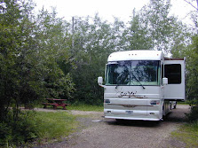
As you can see our new home is deep in the forest. Even through the sun is shining, we also need to turn the lights on inside the coach as it is fairly dark in the coach.

Saturday, July 30, 2011

Day 31–Copalis Beach–July 30, 2011


This is our last day on the coast, tomorrow we will head more inland and north to Hoodsport Washington. We took a short drive back to Ocean Shores to pickup some seafood for tonight’s dinner. I will have crab and Raija decided on clam chowder.

There is a strange tree growing on the property adjacent to the RV Park. Raija suggested that I post it to see if anyone could provide the correct name.

IMG_0297


Tree Fruit


Can you identify this tree?

Friday, July 29, 2011

Day 30–Copalis Beach WA–July 29, 2011


Today was just a quiet, restful day at the Dunes Resort RV Park. The sun came out after the morning fog burned off and the temperature made it to 70°  F.

I took Mik for a run on the beach in the afternoon. He is getting a little braver about the water. He waded in a creek that was flowing on the beach. He still didn’t want anything to do with ocean even through the waves were very small.

Day 29 – Olympic Rain Forest Washington – July 28, 2011


We spent the day driving and several small hikes in the Olympic Rain located in western Washington State. We drove the 31 mile loop around Quinault Lake. The lake is in glacial-carved Quinault Valley of the Quinault River. Lake Quinault is owned by the Quinault Indian Nation. Annual precipitation ranges from 141 to 165 inches (360 to 420 cm). Summers are relatively dry, but only by comparison to the rest of the year.

The dominant species in the rainforest are Sitka Spruce, Douglas-Fir, Western Red Cedar and Western Hemlock some of which grow to tremendous size, reaching 312 feet (95 meters) in height and 23 feet (7 meters) in diameter.

IMG_0283

IMG_0284

IMG_0286

Nurse Stump

IMG_0288

IMG_0289

Lake Quinault

IMG_0290

IMG_0292 

World’s Largest Sitka Spruce

IMG_0294

Elk bedded down in Willaby Creek

Olympic Rain Forest Video

Wednesday, July 27, 2011

Day 28 – Ocean Shores Washington – July 27, 2011


A short ride back down the coast took us to the town of Ocean Shores. There is an IGA Grocery store in Ocean Shores which is the closest grocery store of any size to where we are staying.

In route we stopped at two Washington State Parks. I have to say that Washington is ripping off both their own citizens and the tourist with their new $10 a day or $30 annual passes required to visit a state park. Several of the parks that we have stopped at only have a picnic table or two and a bathroom. One must have a park pass to see nothing at these parks. Who wants to spend $10 for a park that has nothing to offer? Also the state parks with RV facilities are more expensive then the private parks that offer more amenities plus you still have to add park pass fee that make it even more outrageous. I foresee a big decline in park visitors.

We scouted out the town of Ocean Shores, found the grocery store and an ice cream store. Mik needed some ice cream so we stopped and treated ourselves to raspberry cheesecake ice cream and vanilla for Mik.

After that it was time for a ride on the beach before going grocery shopping. I figured that I had better do a video of a Washington beach before we lose the sun.

Ocean Shores Beach Video

Day 27– Copalis Beach Washington - July 26, 2011


The car / camper club left in the morning. Last evening they aligned their cars and trailers as if they would be ready for an early morning, quick departure but it took them until around 10:00 AM to depart. The engine start signal was one of the ladies waving her bra on a pole.

There was more entertainment after lunch. Two large fifth wheel rigs arrived and one of them had a very difficult time positioning his rig in the space beside us. It took nearly two hours for them to get set up. Just when it look like they were all set, they decided that they didn’t like it here and left. That was good news to us as they had crowded us in with very little space between our coach and their rig.

The sun finally came out and no rain. The high was around 62 F and the low 48 F.

Mik really enjoys running loose on the beach and checking out all of the smells. I tried to coach him down to the water but every time a wave heads in, he goes running to higher ground and even scowls me when I get to close too the water.