Saturday, July 31, 2010

Days 75 & 76 – Ninilchik Beach


The rain continues to fall and the sky remains overcast. It appears that our last day on the beach will be more of the same, rain and no sun. Temperatures are still the magic 52 during the day and down to the low 40’s at night.

So far we have had to use the furnace every night since leaving the lower 48 and for the past week even run the furnace during the day. We are experiencing a very cool summer.

We have reached the most westerly part of our journey and tomorrow is the start of our return although we will not be traveling very far, just 40 miles to Soldotna where we will spend seven days at the Edgewater Lodge and RV Park on the Kenai River. We will then have to back track all the way back nearly to Watson Lake. Since we will be back tracking, we will put in longer driving days and not take a driving day break until we get back to Tok.

Just before Watson Lake, we will turn on the Cassiar Highway which will end our back tracking. The Cassiar Highway will take us through Jade City, British Columbia, population 50, and then to Hyder Alaska, population 100. Hyder will be our last Alaskan stop.

Thursday, July 29, 2010

Days 73 & 74 – Ninilchik Beach


Up until today, the Ninilchik Beach has been fairly quiet. Yesterday a group of locals arrived and set up a fishing camp next to us complete with freezer and a generator to power the freezer. They will be here two weeks to catch their winter’s supply of fish.

Yesterday we drove to Homer for lunch and groceries.

Homer was named for Homer Pennock, a gold mining company promoter, who arrived in 1896 on the Homer Spit and built living quarters for his crew of 50 men. However, gold mining was never profitable in the area.

D161 Homer Kachemak Bay Homer Spit jutting out into the bay

Coal was discovered in the area in the 1890s. The Cook Inlet Coal Fields Company built a town, dock, coal mine, and a railroad at Homer. Coal mining in the area continued until World War II. There are an estimated 400 million tons of coal deposits still in the area. Large junks of coal are deposited on the beaches by the tides. During low tide, locals drive on the beach and harvest the coal for heating in the winter.

D194 Deep Creek Beach  Fishing Boat Retrieval – Ninilchik Beach

Wednesday, July 28, 2010

Day 72 – Ninilchik Village


We took a short drive to Ninilchik Village today. The village is the original site of Ninilchik where the Ninilchik River flows into Cook Inlet.

 IMG_0577


IMG_0578

Russian Orthodox Church above old village. 

Ninilchik Village

It appears that the local cell phone tower is having problems as I have been plagued with a very slow internet for the past two days plus last night even the cell phone could not connect even through it showed a signal strength of four bars. It is all part of being in Alaska, service comes and goes.

Monday, July 26, 2010

Day 71 – Ninilchik AK

It rained all last night and the rain has continued throughout today. The forecast is for more rain tomorrow. Today has turned into a camp day due to the rain. Not much to do but relax, catch up on some reading and watch the tide go out and come in.

The tides are quite impressive here. High tide was 21.14 feet and low tide was -1.71 feet, a change in water level of 22.85 feet right in front of the coach. At high tide the water edge is just a 20 feet from the coach. At low tide, it over a 100 yards away.

IMG_0576 High Tide 

IMG_0575

Low Tide

Ninilchik originally was a Dena'ina Athabaskan lodging area used for hunting and fishing. The name Ninilchik was most likely derived from Niqnilchint, a Deni'ana Athabaskan word meaning “lodge is built place”.

The first people who would permanently stay in the village were from Kodiak Island. They were Russian Grigorii Kvasnikov and his Russian-Alutiiq wife Mavra Rastorguev (daughter of Agrafena of Afognak), and their children. They moved here in 1847 before the Alaska was purchased from Russa. The 1880, United States Census listed 53 "Creoles" living in Ninilchik in nine extended families. All nine founding families of Ninilchik are descendants of the Kvasnikovs and Alaska Natives.

The Russian language was spoken widely in Ninilchik among members of the old families as late as the mid-1950s and it is still understood and occasionally spoken by a few older people in Ninilchik today.

Sunday, July 25, 2010

Day 70 – Palmer AK to Ninilchik AK

Today’s Mileage 223
Miles to Date 5878
Miles Remaining to home 4107

Today was one of our longest driving days both in mileage and hours. The portion of the drive from Anchorage down the Sterling Highway was also one of the more scenic drives of the trip. However, it was foggy, raining and very windy so we were not able to get and footage of the scenery. Hopefully the return trip weather will be better.

We how have completed the last leg of our journey up to Alaska. We will be staying on the Kenai Peninsula for two weeks and then start the return trip home.

We are dry camping on the Ninilchik Beach also known has Deep Creek Beach; cost is $10 a day. Ninilchik Village is located at the mouth of the Ninilchik River. It was settled at the turn of the 19th century.

Ninilchik Beach

Saturday, July 24, 2010

Day 69 – Tazlina River to Palmer

Today’s Mileage 150
Miles to Date 5655
Miles Remaining 4001

A little more progress was made today towards the turnaround point, Kenai Peninsula, of our venture. We are now just a day’s drive away for a late Sunday afternoon arrival.

Today started out sunny but as we arrived in Palmer, the sky became overcast and for the last several hours we have had a steady rain.

The Glenn Highway winds alongside the Matanuska River Valley. Across the river is theIMG_0571 Matanuska Glacier. The Matanuska Glacier heads into the Chugach Mountains and is 27 miles long. Some 18,000 years ago the glacier reached all the way to the highway. The glacier average width is four miles. The glacier has remained fairly stable for the past 400 years.

Due to the low lying clouds, I was only able to capture the valley. Hopefully on the return trip, I will be able to get a shot of the glacier.


Just before Palmer is a Musk Ox farm. Musk Ox are survivors from the ice age and once roamed  throughout Europe and North America. There are still wild Musk Ox herds left in the arctic regions. They have been tried to be domesticated with limited success as they maintain their very aggressive behavior.

IMG_0572
Young female Musk Ox

IMG_0574  
Mature Male Musk Ox

Matanuska River Valley & Musk Ox Video

Day 68 – Valdez to Tazlina River

Today’s Mileage 115
Miles to Date 5505
Miles Remaining 4151

We backtracked up the Richardson Highway, AK 4, from Valdez towards the Glen Highway, AK 1. We did not quite make it to the Glen Highway Junction through. We came to a large pullout by the Tazlina River and decided to have lunch. During lunch we checked the distance to the Kenai Peninsula and decided to spend the night where we were as we didn’t want to arrive on the Kenai Peninsula in the middle of the weekend. The Kenai Peninsula will be filled with locals from Anchorage in addition to tourist.

Today’s driving was mostly in rain and low clouds so I didn’t take any pictures besides plus the highlights of the Richardson Highway was covered on the way to Valdez.

Temperatures are still running in the low 50’s during the day and the low 40’s at night.

Day 67 – Prince William Sound Cruise

Today was spent on a seven hour Prince William Sound Cruise aboard the Valdez Spirit.

The pipeline from Prudhoe Bay terminates in Valdez. An average of 52 tankers per month dock in Valdez, each tanker averages 1.2 million barrels of oil. All oil is presently shipped to American ports. The current administration has the pipeline operating at 1/3 capacity due to limits of oil exploration in Alaska. Yet Obama claims he wants America to become energy independent.

Part 1 Video – Leaving the harbor

We left Valdez Harbor and soon came by a group of sea otters resting in the Valdez Arm. Sea Otters are known as the “Old Man of the Sea”. They consume nearly 25% of their weight each day. The rest of the time they float on their backs grooming and resting as this group was doing.

IMG_0548

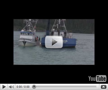
We next came above a fairly large group of fishing boats that are based at Valdez. The boats are individual own and fish for various fish a good part of the year. This time of year they are fishing for salmon. When a boat has a full load of salmon, he sells the load for cash to one of the waiting tenders. The tenders are from different fish companies based in Alaska and Washington State. They bid on the load from the fishing boat. Once a boat has sold and emptied his load, he redeploys his nets for another catch. The current going price for today was 37 cents a pound.


Part 2 Video – Salmon Fishing Fleet

Next on our cruise was Bligh Island, named for Captain Bligh who explored the area as Master of HMS Resolution, under the command of Captain Cook. Today Bligh Island is home to the pilots that guide the large ships through the Valdez Arm and Prince William Sound.

One of the major lessons of the Exxon Valdez oil spill was that the spill prevention and response capability in Prince William Sound was fundamentally inadequate.

The U.S. Coast Guard now monitors fully laden tankers via satellite as they pass through Valdez Narrows, cruise by Bligh Island, and exit Prince William Sound at Hinchinbrook Entrance. In 1989, the Coast Guard watched the tankers only through Valdez Narrows and Valdez Arm.   

Two escort vessels accompany each tanker while passing through the entire sound. They not only watch over the tankers, but are capable of assisting them in the event of an emergency, such as a loss of power or loss of rudder control. Ten years ago, there was only one escort vessel through Valdez Narrows  

Specially trained marine pilots, with considerable experience in Prince William Sound, board tankers from their new pilot station at Bligh Reef and are aboard the ship for 25 miles out of the 70-mile transit through the Sound.  Weather criteria for safe navigation are firmly established.


Part 3 Video – Bligh Island

IMG_0551

A little farther out, we passed by a flow of ice from the Columbia Glacier.

Part 4 Video – Passing through Ice Field

IMG_0553

Steller Sea Lions average 1,200 pounds for males and up to 650 pounds for females. They eat during the night and, sunning and resting on rocks during the day. Bull Head is mostly a bachelor colony.


Part 5 Video – Bull Head colony Sea Lions

Next we came above a Humpback Whale and her calf. These whales are baleen feeders, consuming nearly a ton of food a day, mostly plankton and krill. They migrate 6000 miles to reach their summer feeding grounds in Alaska. Humpbacks average 45 feet and weigh 35-45 tons.

Unfortunately I was only able to catch the mother and calf spouting and did not catch them breaching out of the water. The video does include a Horn Puffin. Puffins are deep divers and fast swimmers. Unlike other birds, they have solid bones instead of hallow bones so that they can dive deeper. This does have one drawback as sometimes they eat too much and cannot take off from the water. They than just have to wait until they become light enough to fly. Usually they can avoid predators by swimming fast and diving until they are light enough to fly.


Part 6 Video – Humpback Whale & Puffin

IMG_0556

For Loren: Sailboat in Prince William Sound

I guess they like cold water sailing vs. Gulf of California.

 IMG_0559IMG_0564IMG_0565

Columbia Glacier

The Columbia Glacier was the last of Alaska’s tidewater glaciers to go into retreat. The retreat began in 1978 and by 1983 it had moved off of its terminal moraine, losing an increasing amount of ice. In 2002, it had retreated for a distance of 7.5 miles, leaving approximately 18 miles to go before reaching bedrock on shore. Glaciers retreat and proceed in cycles. The cycles are not related to global warming as Al Gore and President Obama say is evidence of global warming. As a matter of fact several glaciers in Alaska are in their proceeding cycle.


Part 7 Video – Columbia Glacier

IMG_0567

Sea Lions resting on a buoy – Actually showing off for us.

Anderson Falls is created by melting ice from Anderson Glacier that is east of Columbia Glacier. Anderson Falls brings our cruise to an end.

Part 8 Video: Sea Lions and Anderson Falls

Wednesday, July 21, 2010

Day 66 – Valdez Glacier Campground to Bayside RV Park, Valdez, AK


Today’s Mileage 5
Miles to Date 5390
Miles Remaining 4266

Yes, today’s total mileage is correct! We drove just five miles from Valdez Glacier Campground to Bayside RV Park in downtown Valdez. We were running low on water and the holding tanks were getting full. We now have full hookups and have the Reverse Osmosis generator running to fill the fresh holding tank. Plus it gives us a chance to catch up on the laundry.

And yes, we added five miles to the total miles remaining as we will need to back track the miles driven today to continue our trip to Anchorage.

 IMG_0544
Valdez Harbor


IMG_0545

IMG_0546

Valdez Harbor Streets

The harbor area is the busiest part of town this time of year due to the tourist fishing season. Add about another half dozen streets of more of the same and one has Valdez covered. Actually Valdez is a couple of blocks larger than the typical Montana town that has the highway as the main street and one block on either side of the highway by about four blocks along the length of the highway.


The weather changed a little for the better today. It rained all last night and into the morning hours of 10:00 plus. This after there was a break in the clouds and one could actually see blue sky. The temperature made it up t 62 F after a low of 39 F around 3:00 AM.

Tuesday, July 20, 2010

Day 65 – Worthington Glacier

Worthington Glacier is located in the Chugach Mountains near Thompson Pass, the snowiestIMG_0541 place in Alaska. Worthington Glacier is one of the most accessible glaciers in Alaska, passing within a few feet of the parking lot and viewing shelter right off the Richardson Highway.

Like most of Alaska’s glaciers, this valley glacier has been steadily retreating for the last 150 years, but not as dramatically as many others. The upper basin sits at 5,500 feet and collects about 28 feet of snow each year.


IMG_0540

The glacier is named for the transit man of an 1899 survey party mapping an ice-free corridor to Alaska’s interior who survived being swept away in a glacial stream.

IMG_0542 
Stream & Falls - Melting ice from Worthington Glacier

IMG_0538 IMG_0539

IMG_0543 
View from Thompson Pass


Last evening we drove back to Solomon Gulch to see if any bears might be feeding on the salmon. There were no bears but the tide was in and the water was deep enough for sea lions to feast on the sprawling salmon. The salmon crowded into the shallow portion of the stream outlet and you could see them panic whenever a sea lion approached. There were at least 5 large sea lions and several sea otters. The sea otters seemed to going after pieces of salmon dropped by the sea lions.

Sea Lions Feasting on Salmon

Monday, July 19, 2010

Day 64 – Old Valdez, Valdez Glacier & Salmon Run

The original town of Valdez was located four miles east of its present position and closer to Valdez Glacier. The Good Friday quake of 1964, the most destructive earthquake ever to hit south central Alaska, virtually destroyed Valdez. The earthquake was centered in Prince William Sound and measured 9.2 on the Richter scale. A series of local waves first emptied the harbor and left ships sitting on the harbor floor and then the harbor filled with a huge wave that engulfed the Valdez wharf taking 33 people with it.

After the quake, the Army Corp of Engineers determined that the town should be relocated. By late 1964 relocation was underway. By late August of 1968 the remaining residents of “Old Valdez” move to the new town.

IMG_0534

Foundation of original Post Office in “Old Town”

IMG_0533

IMG_0535

IMG_0536

The city lies on the north shore of Port Valdez named in1790 by Spanish explorer Don Salvador Fidalgo for Antonio Valdes y Basan, a Spanish Naval Officer.

Valdez was established in 1897 as a port of entry for gold seekers bound for the Klondike gold fields. The Valdez trail was especially dangerous as the first part led up over the Valdez Glacier, where early stampeders faced dangerous crevasses, snow blindness and exhaustion.

Due to the low hanging clouds and fog, I was unable to get any photographs of Valdez Glacier. I did get some footage of Valdez Glacier Lake at the base of the Glacier. The lake has chunks of ice floating in it that have broken off of the glacier.

The salmon have started their run at Solomon Gulch. You can see the salmon of them in the attached footage.

IMG_0537

Young eagle waiting his chance for salmon


Sunday, July 18, 2010

Day 63 – Kenny Lake to Valdez Alaska

Today’s Mileage 91
Miles to Date 5385
Miles Remaining 4266

We drove back to the Richardson Highway from Kenny Lake, turn left and arrived in Valdez around 1:00 PM. We will be spending the next three nights at the Valdez Glacier Campground. The campground has 30 & 20 amp electrical but no water or sewer for $25 per night.

We started the day in clear skies but as we approached the coastal mountains with large glaciers we ran in fog, clouds and then rain. It is presently raining and the mountains are obscured in the clouds.

As I mentioned previously, the glacier mountains make their own weather, which was very obvious as we approached the Worthington Glacier that is very near the highway.

IMG_0528
Worthington Glacier

You can see the fog being created by the Glacier.

The drive is very scenic as the road follows the Copper River for a while and then works its way along side several rivers whose source are the glaciers. Closer to Valdez the highway passes by Bridal Falls and then Horse Tail Falls.

IMG_0530
Bridal Veil Falls

IMG_0531
Horse Tail Falls


The Trans-Alaska Military Pack Train through Keystone Canyon that led to the first glacier-free land route from Valdez to the interior originates near Bridal Falls. The first gold rush trail led over the treacherous Valdez Glacier, then northeast to Eagle and the Yukon River route to the Klondike goldfields. Captain W. R. Abercrombie and the U.S. Army Copper River Expedition of 1899 rerouted the trail through Keystone Canyon and over Thompson Pass, thus avoiding the glacier. The military kept the trail open to connect Fort Liscum in Valdez with Fort Egbert in Eagle even after the gold rush ended. In 1903, the U. S. Army Signal Corps laid the trans-Alaska telegraph along this route.

Saturday, July 17, 2010

Day 62 – Wrangell Mountains & Liberty Falls

Before I forget again, I need to bring everyone up-to-date on the cinnamon bun first place holder. While the Chicken, AK cinnamon bun was quite good, we can only move it to first place. The Village Bakery at Haines Junction is still the first place holder.

This morning was spent figuring out how to restore the jack in the H3, recalibrating the H3 built in tire monitoring system and getting the tire repaired. The latter was a little tricky. The tire repair shop at Kenny Lake is a one man shop in back of the Mercantile Store and his hours are 8 to 5 Monday through Friday and today is Saturday. The day was saved as the Kenny Community is having a yard sale in the field behind the Mercantile Store and the tire repairman and his family have a table of items for sale. He graciously open his shop and repaired the tire with an inside patch for $15.00.

This got us to lunch time so I cooked up some cheeseburgers.

The sun was out so it was down the road to see if the Wrangell Mountains were in the clear. Due to the huge ice field, the mountains make their own weather. Although the whole sky was clear, there were still clouds at the mountain peaks but at least one could see a small section of the massive ice field in one section of the range.

 IMG_0030

IMG_0033

Keep in mind that this is just a small portion of the ice field

IMG_0029

From the same vantage point, one has a good field of the Copper River

Also there is no shortages of waterfalls in Alaska


Day 61 – McCarthy & Kennicott

In 1900 two prospectors, Jack Smith and Clarence Warner spotted a large green spot on the mountainside between Kennicott Glacier and what is now McCarthy Creek. The green patch turned out to be one of the richest deposits of copper ever found. Smith contacted Stephen Birch, a mining engineer to inspect their find. Birch was able to get the backing from the Guggenheim brothers and J. P. Morgan who bought the claims. In 1906 Kennecott Mines Company was formed. The mining company was supposed to take the name of the glacier which was named after Robert Kennicott, an early Alaskan explorer, but the company name was misspelled. The town and glacier are spelled Kennicott but the mines and company are spelled Kennecott.

The ore from mine needed to be transported to Tacoma Washington by the Alaskan Steamship Company for smelting. To accomplish this, a railroad needed to be built to the coastal town of Cordova. Michael J. Heney, a master railroad builder, was hired to build the Copper River Northwestern Railway. Construction began in the spring of 1908 at Cordova to the Kennecott mines, a distance of 196 miles. The CR & NW transported approximately $200 million of copper.

At its peak, the town of Kennicott had around 300 people in the mill camp and another 200 – 300 miners in the mines. The complex had a hospital, store, grade school, a dental office, and dairy along with others buildings needed for the mines operation. Foremen and higher workers were given company housing and allowed to have their families live with them. Lower workers were housed in bunk houses and could not have them families.

Once you have a railroad, other towns seem to spring up. McCarthy sprang up as a railroader’s town and a place for miners to have a bit of recreation. Restaurants, pool halls hotels, saloons, two newspapers, a dress shop, a photography shop, garage and auto repair shop, shoe store, hardware store that provided services to more than 800 people in the area.

In 1938 mining operations ceased due to the drop in copper prices. In November 1938 the last train left Kennicott for Cordova taking the remaining people with it. A few years later, the company gave the CR & NW right away to the federal government. It was given for the purpose of creating a public highway, a gift to the people of Alaska.

Kennecott sold their mining claim and all of the buildings to Consolidated Mining Company. Consolidated thought that they could surface mine but soon discovered it would not be profitable. Consolidated divided the claim into parcels and sold them. Today you will find many of the buildings; especially the old housing for the foremen and higher workers owned and occupied my private families. Also most of the land that was once part of the original claim is privately own. In 1998 the National Park Service bought the milling site and surrounding 3,000 areas of land which became part of the Wrangell-St. Elias National Park.

To get to Kennecott and McCarthy, one takes the highway to Chitina. Chitina is a small town on the where the Copper and Chitina Rivers converge.

IMG_0496 IMG_0494 IMG_0495


At Chitina one takes the McCarthy road. The McCarthy is a dirt road that was once the old railroad right away.

The ride on McCarthy Road

 IMG_0497

Chitina River

 IMG_0498 

One Lane Kuskulana Canyon Bridge


IMG_0500

One Lane Wooden Blank Bridge

There are still old railroad spikes that surface and much of the gravel contains share stones. As we crossed the Kuskulana, we were flagged down by a stranded tour van. The tour driver asked if we could take some of their tourists to McCarthy footbridge. We had room for two, who turned out to be a Swiss couple.

 IMG_0501

IMG_0502

Gilahina Trestle

The trestle was originally 890 feet long and 90 feet high. It required one-half million board feet of timber, was completed in eight days in the winter of 1911. Due to the rugged landscape, over 15% of the entire railway was built on trestles like this one.

 IMG_0503  IMG_0505   IMG_0504

IMG_0508IMG_0507

Kennicott Glacier River

The river water is a light grey and looks like watery concrete but it is not polluted. The river begins as flowing rivers of ice. Millions of tons of rock dust are soured off of distant mountains by glaciers and carried down river each year. The resulting silty waters hide salmon swimming up river to spawn. The water also hides the water paddle wheels from the salmon that natives used to catch the salmon substance for the year.

Drive to McCarthy / Kennecott video

IMG_0509

Foot Bridge to McCarthy and Kennecott

Only local residents are allowed to drive their vehicles across a privately owned bridge. Visitors must cross on the foot bridge. It is a mile walk from the other side of the foot bridge to McCarthy and five miles to Kennecott. Private companies, owned by residents of McCarthy, offer a shuttle service, $10 round trip, from the shuttle bridge to both McCarthy and Kennecott. The shuttle van runs every half hour.

Actually it works out quite well, as it preserves the openness of both places and it allows one to get the feel of life in a small community.

 IMG_0511

Glacier Flour left by the Kennicott Glacier

IMG_0512

Kennicott Concentration Mill

 IMG_0514

West Bunk House

IMG_0515

Hospital, East Bunk House & National Creek Bunk House

 IMG_0517 IMG_0518  IMG_0520 IMG_0519

Inside the Power Plant

IMG_0521

Outside Power Plant

 IMG_0522

Edge of Kennicott Glacier

IMG_0524

Isolated Ice from Kennicott Glacier

IMG_0510

McCarty Depot – Now a museum


Kennecott / McCarthy Video

When we arrive at the parking lot for the footbridge, there were several vehicles getting tires repaired. We made it in okay but half way out we had a flat. I pulled off near another car that was sitting in a clear area off the road. He offered to help which we accepted. It turns out that he is a fisherman that was returning from fishing on the coast who lives in the McCarthy / Kennecott area. He had stopped by the “Fountain of Youth” to refill his water jugs. The “Fountain of Youth” is a spring that the local residents’ legend claims the water provides longevity. Well not only did the fisherman help change the tire; he gave us a nice salmon steak from his catch. He would not take any money for helping or the salmon. He just said that is what folks do up here, help each other out.