Today’s Mileage 166
Miles to Date 3052
Miles Remaining 6370
Today’s big event was crossing the Mackenzie River by ferry and encountering herds of bison grazing along side of the Highway 3 that will take us to Yellowknife. According the Northwest Territories road map there are only 7 highways in NWT. So far we have traveled on four of them, 1, 2, 3 and 5.


Bison are bedded down and grazing along the highway

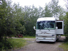
Tonight we are camping on the North Arm of the Great Slave Lake. This area is much like northern Finland not only is the country side, the trees and vegetation much the same, the Great Slave Lake has a northern arm the like Finland.


Tomorrow we will proceed to Yellowknife. We are without cell phone and internet service. We will most likely have only internet service at local library in Yellowknife. We have been told by travelers heading south, that Yellowknife local wireless company is one that Verizon does not contract with.
We will be arriving in Yellowknife during the weekend of Aboriginal Day and the longest day of the year. Included in the celebration is a golf midnight tournament. There is no penalty accessed if your golf ball is carried off by a raven. The golf course is built on Pre-Cambrian Shield. The course is mostly sand and bedrock. Each player is issued a small piece of carpet to take along as their portable turf.

No comments:
Post a Comment